

THE United Nations General Assembly has voted overwhelmingly in favour of an African-led initiative seeking to promote more accurate representation of the size of Africa and other regions on world maps.
The General Assembly on Friday, September 4, adopted a resolution titled “Correct the Map: Rebalancing Global Cartographic Representation and Promoting Equitable Representation of the World’s Regions, Particularly Africa” by 164 votes to one, with six countries abstaining.
The United States was the only country to vote against the resolution, while Estonia, Georgia, Lithuania, Morocco, Serbia and Ukraine abstained.
The resolution was championed by Togo on behalf of the African Group and seeks to promote cartographic representations that more accurately reflect the relative sizes of the world’s regions, particularly Africa.
The vote followed an African-led campaign to change how the continent is represented on commonly used world maps.
#VIDEO: For decades, the world map has made Africa appear smaller than it really is.
The UN has voted to correct the map and support a more accurate representation of Africa’s true size.
Watch the video to find out what the decision means—and why how we see the world matters.… pic.twitter.com/0EwtFXn3ah
— The ICIR (@TheICIR) September 12, 2026
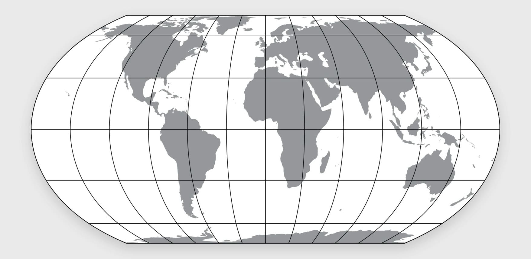
It particularly advances the use of equal-area projections such as the Equal Earth projection, which depicts land masses according to their actual relative areas.
What exactly is being ‘corrected’?
The campaign is centred on the widespread use of the Mercator projection, a map projection developed by Flemish cartographer Gerardus Mercator in 1569.
The Mercator projection was designed primarily for navigation because it preserves angles and makes lines of constant bearing appear straight, a property that made it particularly useful to sailors.
However, the projection does not preserve the actual area of land masses.
The farther a location is from the Equator, the greater the distortion becomes. Countries and territories in the far north and south therefore appear disproportionately large, while regions closer to the Equator appear relatively smaller.
For instance, Greenland, on a Mercator map, appears comparable in size to Africa. In reality, Africa is about 14 times larger than Greenland.
Africa covers about 30.3 million square kilometres, while Greenland covers approximately 2.2 million square kilometres.
The same distortion affects other large territories at high northern latitudes, including Canada and Russia, making them appear substantially larger than their actual area relative to countries closer to the Equator.
Africa’s campaign to ‘correct’ the map
The ICIR reports that the African Union had noted that the issue was beyond cartographic accuracy but that of global representation.
Following the adoption of the resolution, the Chairperson of the African Union Commission, Mahmoud Ali Youssouf, welcomed the vote and commended Togo for championing the initiative on behalf of the African Group.
According to the AU, the Mercator projection, although developed primarily for navigation, does not accurately represent the relative surface areas of the world’s regions and significantly understates Africa’s true size.
The AU said the initiative goes beyond cartography and is intended to promote representation of Africa based on objective and scientifically established geographical realities.
It further encouraged international institutions, educational systems, publishers and digital platforms to progressively promote map projections that more accurately represent actual land areas.
The ICIR reports that the UN resolutions are not legally binding, meaning countries and institutions will not be compelled to adopt the new projection or prohibited from continuing to use the Mercator projection.
The map at the centre of the campaign
Meanwhile, one of the principal alternatives promoted by the campaign is the Equal Earth projection, an equal-area world map developed by cartographers Bojan Šavrič, Tom Patterson and Bernhard Jenny.
The projection was created in 2018 to provide a visually appealing alternative to other equal-area projections. Unlike Mercator, Equal Earth preserves the relative areas of land masses.
This means that Africa’s size relative to Europe, North America and Greenland is represented much more accurately.
The creators of Equal Earth described it as an equal-area pseudocylindrical projection, meaning that all regions retain their correct relative surface areas even though other forms of distortion remain.

Mustapha Usman is an investigative journalist with the International Centre for Investigative Reporting. You can easily reach him via: musman@icirnigeria.com. He tweets @UsmanMustapha_M